

Around Manaslu Trekking
 This extended and strenuous trek, circumnavigating the Manaslu range, is one that avid trekkers could only dream about till a few Years back. Officially opened to trekking in 1990 and just as suddenly forbidden again, it was finally "reopened" in 1992 along with Mustang. A Government quota, however, limits the number of visitors to the area.
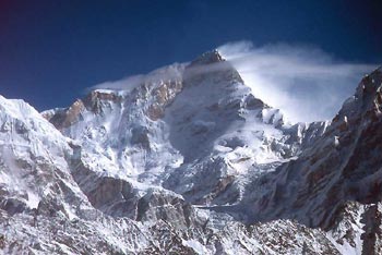
Strenuous trekking is constantly rewarded with brilliant mountain vistas of the Ganesh and Manaslu Himal ranges and insights into the cultures of a cross-section of ethnic Nepalese tribes and peoples, perhaps not available on any other trek.
Starting, in the lush green lower hills inhabited by Indo-Aryan Hindus, you will pass through middle hills which is inhabited by the Tibetan-Burmese, Magar, Rai,Limbu and Tamang peoples who follow both Hinduism and Buddhism and sometimes Shamanism, to emerge into the high, arid desert region that is actually a part of the Tibetan Plateau where people of Tibetan Stock dwell and where the predominant religion is Tibetan Buddhism.
This trip is long and strenuous and the crossing of the Larkya La requires excellent physical conditioning, acclimatization to the high altitude and of course good weather.
- Itinerary
- Cost Info
- Departure
Around Manaslu Trek Itinerary
Day 01: Arrive KATHMANDU. Transfer to Hotel.
Day 02: KATHMANDU
Full Day guided sightseeing around the world heritage site inside the Kathmandu Valley.
Evening, we invite you at the special welcome dinner with Live Nepalese Cultural Program hosted by Makalu Adventures. Overnight at Hotel.
Day 03: KATHMANDU – GORKHA.
After breakfast, board you private transport and start the drive to Gorkha. This drive can take up to five hours and you will need to carry packed lunches, which will be provided. Your, crew will either travel with you or they may be waiting for you in Gorkha.
Gorkha is a picturesque hill top town and is very important in Nepalese history. It was from this town, in 1742 that Prithvi Narayan Shah struck out, with his Gorkha Army and ambition to match, to conquer and unify the territories that is Nepal today. Kathmandu, the present Capital was overrun by his troops in 1768 and much of present day Nepal unified by 1771. The famous Nepalese foot soldiers often referred to as the "Gorkhas" take their name from this town. In that campaign and subsequent wars and battles these soldiers have served well in the Nepalese, British and Indian Armies gaining fame for their loyalty and bravery.
From Gorkha the trailheads north through the village of Sonwara to the village of Taplekakhe where camp will be set up for the first night.
Day 04: GORKHA – ARUGHAT (600 m), 4-5 hrs.
From Taplekakhe head northeast, attaining a ridge to arrive at the village of Kanchok (3116 m.) where lunch will be served. This stop affords magnificent mountain panoramas of the Annapurna, Manaslu, and Ganesh Himal ranges as well parts of Gosainkunda Himal. After lunch, descend down to a small stream and follow it till you reach Arughat Bazaar on the West Bank of the Buri Gandaki river and camp.
Day 05: ARUGHAT – SOTI KHOLA BANK (710 m), 5-6 hrs.
Heading north, along the Buri Gandaki, you pass through lush, cultivated fields to the villages of Mordar and Simre. Crossing the Arket Khola, a tributary of the Buri Gandaki you pass through the village of Koyapani to Soti Khola (another tributary of the Buri Gandaki on whose banks camp will be set up.
Day 06: SOTI KHOLA BANK - KHANI GAON (890 m), 6-7 hrs.
Descend to the Buri Gandaki river and then climb, still heading north to the village of Almara. From Almara the trail leads through the villages of Riden and Lapbesi to Khani Gaon.
Day 07: KHANI GAON – DOBAN (1000 m), 5-6 hrs.
Cross the Maccha Khola (fish river), which flows into the Buri Gandaki to Kholabensi and then to the village at Tatopani which means "hot springs". At Tatopani you cross the bridge over the Buri Gandaki to the east bank and proceed to the village of Doban, at the confluence of the Buri Gandaki and the Doban Khola. In fact, the name Doban means "confluence".
Day 08: DOBAN – JAGAT (1,410 m), 5-6 hrs.
Crossing the Dodan Khola you trek to the village of Lauri and cross the Buri Gandaki to its west bank, to the village of Jagat. At Jagat there is a police check post where your trekking permits will be checked.
From Jagat you first walk northwest, slightly away from the Buri Gandaki and then turn north again to reach the village of Setibas.
Day 09: JAGAT – SHAR KHOLA (1,964 m), 6 hrs.
Cross to the left banks of the river via a suspension bridge and continue following the river to Serishe Gaon. From Serishe Gaon, the trail leads to Nyak. Enroute, you have to cross Chulung Khola and Shar Khola.
Day 10: SHAR KHOLA – UNBAE (2,330 m), 6-7 hrs.
Continue along the river to the village of Deng. It is a tiny village of about four houses. The precipetuous cliffs of the previous few days end but, the mountainside are quite steep and the valley a deep "V". Crossing to the opposite bank along a suspension bridge and then climbing up the steep mountainside you reach the village of Lana. From Lana there is a gentle descent past the village of Unbae, which has a stone gateway, and walls lined with Mani stones, a distinctive reminder that you are now among people of Tibetan descent.
Mani stones prayer flags and prayer wheels occupy a very important place in Tibetan Buddhism. It is believed that passing a Mani wall on its left side means that the prayers written on the Mani stones are automatically said on behalf of the traveller. The prayer flag does the same thing but, for those who string them up, by using the wind. The prayer wheel is used while travelling and is spun clockwise using the hand.
Descend to the riverbed and climb the terraced hillside to the village of Bhir Gaon to camp.
Day 11: UNBAE – NAMRU (2,660 m), 5-6 hrs.
Cross the Shringi Khola to reach the village of Ghap. Along the way Shringi Himal (7187 m.) is visible to your right. Cross the wooden suspension bridge beyond Ghap and follow the path to Lumachik. From Lumachik, you have to ascend a forested path to the village of Namru. Namru has a police check post and you will be required to show your trek permits here.
Day 12: NAMRU – SAMA GOMPA (3,470 m), 6-7 hrs.
Leaving Namru, you cross a stream and after a short walk across a grassy meadow from which you see a waterfall to your left you cross some pastures to the village of Bengsam. From Bengsam, climb the mountainside to the village of Li, cross the Hinan Khola and enter the village of Sho through its stone gate. Past this village, magnificent mountain vistas begin opening up. First Naike Peak Manaslu North 7157 m and finally, Manaslu itself at an imposing 8163 m. Climbing a gradual slope through fields you arrive at the village of Lo (3150 m.) with its walled fields (to keep domestic animals out) and the splendid backdrop provided by Ganesh Himal (7429 m.). Descend from Lo along a winding trail, cross the Damonan Khola and Shara Khola and climb up a ridge to reach Sama Gaon (3450 m.). Camp near Sama Gompa, about 20 minutes away from Sama Gaon.
Day 13: SAMA GOMPA – SAMDO (3,690 m). 6-7 hrs.
The initial walk starts out on level ground, skirting a lateral moraine to reach the Buri Gandaki which now begins to look more like a stream and not a river, as you get closer to its source. Passing through pastures at Kermo Kharka, from where there are excellent views of Mt. Manaslu, you reach Kermo Manan the walk from Sama Gaon takes you to Samdo, the most remote permanent settlement along the trek. En-route to Samdo, you have to cross a stream that originates in the Manasalu glacier and pass through Kermo Kharka (which offers an excellent view of Manasalu) and Kermo Menan with its long Mani Walls. Camp at Samdo.
Day 14: SAMDO – REST DAY.
Rest day at Samdo. This day allows you to acclimatize and adjusts to the high altitude. Samdo is the most remote permanent settlement that you will visit on this trek. Samdo has about 40 houses and is inhabited by about 250 people living under the most severe conditions.
Day 15: CROSS THE LARKYA PASS (5,150 m) 7-8 hrs.
Descend a gently sloping mountain path, cross the Gyala Khola, and then climbing up another gentle slope you will see the remains of Larkya Bazaar, once a thriving trading post for Nepalese and Tibetan traders, now a ghost town. From here, you will cross two streams and climb up a hill to a shelter build for those crossing the Larkya La. The day's camp is made either at the guesthouse (4450 m.) or in a valley at a higher elevation.
Day 16: CAMP – TANBUCHE (4,450 m), 5-6 hrs.
The ascent is gentle and Larkya Peak, uniquely shaped, becomes visible. Later, the gentle slope becomes a steep hill and leads up to the to Larkya La (5150 m.). Great Himalayan panoramas unfold. Himlung Himal (7126 m.), Cheo Himal, Gyaji Kang, Kang Guru (7937 m.) and Annapurna II (7937 m.) rise in true Himalayan splendour to the west. Unlike the ascent, the descent is steep and often snow covered but, offers splendid views on the way to Pangal and Larcia. Continue downhill to the one hut at Tanbuche.
Day 17: TANBUCHE – KARCHE (2,760 m), 5-6 hrs.
You walk along a wide level valley to Bimtang. From Bimtang, you descend to the Dudh Khola riverbed and follow the route to Manasalu Base Camp. Cross the Dudh Khola by a wooden bridge and descend through a magnificent rhododendron forest to Hampuk, Sangure Kharka and across the Surki Khola to Karche. Camp for the night is at Karche. The rivers and streams that you encounter now are a part of the Marsyangdi river system.
Day 18: REST DAY TO EXPLORE THE SURROUNDING.
Day 19: KARCHE – THONJE (1,930 m), 6 hrs.
From Karche, a trek up the hillside through terraced paddy fields takes you to Karche La. You cross the pass and descend to Goa on the Right Bank of the Dudh Khola and continue to Tilije. From Tilije cross to the left bank via a wooden bridge and continue to descend along the Dudh Khola, drawing closer to the Marsyangdi Khola. Cross to the Right Bank via a wooden bridge to Thonje.
Day 20: THONJE – CHAMJE (1,410 m), 5 hrs.
From Thonje, cross the river and ascend to Darapani, and walk above the ridge to an open place, Tal. Descend along the ridge to Chamje, where camp is set, usually under the bridge by the river.
Day 21: CHAMJE – NGADI (950 m), 4-5 hrs.
From Chame cross a bridge and pass through the village via jungle trail that follows the Marsyangdi river. Through the west bank you reach Syange where there are a couple of teashops and a lodge, catering mostly to people going on a circuit of the Annapurna Himal, up the Marsyangdi river valley. Cross the river again and begin a fairly level walk. You then have to climb up a hill before to reach the village of Bahundanda. This village is mainly populated by members of the Bahun (Brahmin) community and hence the name. From here, descend to Ngadi Khola where you will find the camp for the night set up by the river across the bridge. There are many teashops and lodges owned by Gurungs, Mananges and Brahmins.
Day 22: NGADI – BESISAHAR (8,20 m), walk of 4 hrs. – KATHMANDU (Drive of 4 hrs).
Today's walk involves fairly level walking through rice fields to the village of Simalchour. From here, following the path along the West Bank of the river, the trail gradually climbs up and then descends to Besisahar from where you will meet the road that will take you to Kathmandu via Dumre. There is an option of doing a white water trip from Besisahar to Dumre, when the water level is right but this has to be booked at the time you book your trek.
If you take this option you will join the motorable road at Dumre for the drive to Kathmandu. Overnight Hotel.
Day 23: KATHMANDU FREE DAY.
Day 24: FINAL DEPARTURE.
Trip Cost : USD 1850 Per Person
Included Services:
- All ground transfers as per our itinerary. (Airport-Hotel-Airport).
- Three star Hotel in Kathmandu Thamel Eco resort (Twin Sharing, Bed and breakfast basis inclusive of all Tax)
- Welcome Dinner with Live Nepalese Cultural Program hosted by Makalu Adventures.
- Guided sightseeing around world heritage sites of KTM.
- Transfer: Kathmandu -Gorkha - Besisahar - Kathmandu.
- Fully organized camping trek arrangement (Including all high quality camping equipments like two men tent, dinning tent, kitchen tent, tables, chairs, mattresses, hot water bags, pillows and other utensils).
- Three times meals a day while trekking, which will be prepared by our very professional kitchen crew (eg. bed tea, breakfast, tea, coffee, lunch, tea / biscuits, dinner).
- Manaslu and Annapurna Conservation Area Entrance Fees.
- Special Trekking Permit (Necessary!) to trek on the Manaslu Area.
- Guides, porters and their daily wages, insurance with all necessary lodging - fooding arrangements.
Excluded Services:
- All International Airfares / Airport Taxes.
- Expenses of personal nature such as bar bill, laundry bill, telephone bill, tips and etc.
- Personal medical and travel insurance.
- Helicopter Rescue & Evacuation - If needed.
| Fixed Departures Dates for 2021 | Fixed Departure Dates for 2022 |
| March 01.03.2021 14.03.2021 28.03.2021201 |
March 03.03. 2022 17.03. 2022. 29.03. 2022 |
| April 01.04.2021 10.04.2021 19.04.2021 29.04.2021 |
April 02.04. 2022 07.04. 2022 14.04. 2022 27.04. 2022 |
| May 02.05.2021 11.05.2021 17.05.2021 23.05.2021 30.05.2021 |
May 03.05. 2022 10.05. 2022 18.05. 2022 24.05. 2022 31.05. 2022 |
| June 09.06.2021 15.06.2021 27.06.2021 |
June 05.06. 2022 16.06. 2022 30.06. 2022 |
| July 05.07.2021 13.07.2021 20.07.2021 33.07.2021 |
July 07.07. 2022 14.07.2022 21.07.2022 31.07.2022 |
| August 06.08.2021 15.08.2021 30.08.2021 |
August 07.08 .2022 13.08. 2022 28.08. 2022 |
| September 02.09.2021 17.09.2021 28.09.2021 |
September 09.09.2022 15.09.2022 25.09.2022 |
| October 01.10.2021 07.10.2021 17.10.2021 27.10.2021 31.10.2021 |
October 02.10.2022 06.10.2022 16.10.2022 26.10.2022 30.10.2022 |
| November 02.11.2021 11.11.2021 18.11.2021 29.11.2021 |
November 04.11.2022 13.11.2022 20.11.2022 30.11.2022 |